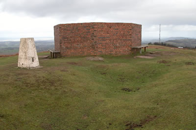
People are often intrigued by the brick structure at the summit of Garway Hill. It seems to have no purpose. Sure, it is a handy shelter from the wind when it is blowing hard up there, and the seats around the outside are a welcome discovery when you have toiled your way up from the bottom of the hill on a hot day. But that is not the real reason it is there.
What you see is an octagonal laid brick wall, approximately 2m high and 7m in diameter and standing upon a concrete foundation with a further eight individual concrete foundations equally spaced around the outside. These have rectangular indentations and were evidently designed to support something. So what could it be?
It can now be revealed as the remains of a Second World War Radio Tracking Station. It was erected in 1942 by order of the Royal Air Force. The whole station stood approximately 8m high, the mixed brick and concrete foundations having supported a timber built tower not unlike that of a windmill. The photograph shown on this page is believed to be the only one in existence which shows the full structure.
From this you can see that the indented concrete foundations were designed to house the upward slanting beams which stabilised the upper tower.
Directly south and west of the tracking tower site are the remains of two foxholes/trenches and a square trench which surrounds the structure shows where a fire-break trench was dug.To the northeast, on the down slope of the hill, are the remains of the barrack blocks. these are similarly surrounded by firebreak earthworks . The foundations of the barrack block are all that remain following its demolition during the 1970’s. On the edge of the Common boundary, there are also the remains of the generator block consisting of a concrete foundation with evidence of collapsed brick walls scattered on the interior.
The tracking station was designed as an to aid to navigation for any aircraft unsure of where it was. By getting two bearings from different tracking stations, the navigator could plot the two lines on a chart and where they met this would indicate the aircraft’s position. During the war there would be a constant stream of training missions and real bombing missions crossing the local airspace. Accurate navigation was especially important near mountains, and the Brecon Beacons claimed its fair share of crash victims during the war. Tracking stations like the one on Garway Hill would have saved the lives of many bomber crews – perhaps inexperienced trainees or perhaps the occupants of damaged aircraft trying to get home.
The upper part of the tower was dismantled in 1948, leaving the brick and concrete base as an enigmatic trace of its brief existence.
The design of the tracking station was evidently standard. There is an almost identical set of remains from an old wartime station on Shetland at Esha Ness.

