Category Archives: Information for Visitors

Funghi on the hill, October 2012

The 2012 survey of funghi on Garway Hill Common took place on 18th October.

Regular readers will know that the reasons for undertaking the annual survey are twofold: it acts as an indicator of the effectiveness of the Commoners’ Association’s environmental management scheme and it provides a good walk on the hill in the company of an experienced naturalist. This year, mycologist Sheila Spence of Marches Funghi once again led the walk. After a long wet summer the autumn weather was continuing the theme and the days prior to the walk had been wet enough for the occasion to be called off, but on the day we got a dryish but overcast day. It was decided that the 2012 walk would concentrate on the western slopes of the hill

The following species of funghi were observed:

Bovista plumbea Grey Puffball
Calvatia (Handkea) utriformis Mosaic Puffball
Clavaria fragilis White Spindles
Clavulina corniculata Meadow Coral
Clavulinopsis helvola Yellow Club
Clavulinopsis luteoalba Apricot Club
Clytocybe clavipes Club Foot
Clytocybe vibecina Mealy Funnel
Collybia fusipes Spindle Toughshank
Coprobia granulata Cow Pat fungus
Hygrocybe chlorophana Golden Waxcap
Hygrocybe glutinipes Glutinous Waxcap
Hygrocybe insipida Spangle Waxcap
Hygrocybe pratensis Meadow Waxcap
Hygrocybe reidii Honey Waxcap
Lactarius quietus Oakbug Milkcap
Lycoperdon nigrescens Dusky Puffball
Lycoperdon perlatum Common Puffball
Macrolepiota procera The Parasol
Mycena flavoalba
Ivory Bonnet
Mycena galericulata Common Bonnet
Mycena pura Lilac Bonnet
Rickenella swartzii Collared Mosscap
Mycena epipterygia Yellowleg Bonnet
Russula heterophylla Greasy Green Brittlegill
Vascellum pratense Meadow Puffball

The different environment on the western side of the hill resulted in several new species being observed. Generally, the numbers of funghi were fewer than in previous years. Whether this was due to the exceptionally wet and cool weather which had characterised 2012 from April onwards, or whether it was due to the earlier timing of the walk (2011’s walk was in November) is hard to say.

However, there was a delicious bonus for two of the participants – two large parasols made good eating later in the day.

(A word of caution – very few of the funghi to be found on Garway Hill are edible, so do not be tempted to eat anything you find unless you are certain about what you are doing. Some will make you feel very ill, many just taste horrible.)

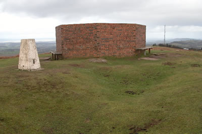
The Brick Structure at the Summit of Garway Hill

People are often intrigued by the brick structure at the summit of Garway Hill. It seems to have no purpose. Sure, it is a handy shelter from the wind when it is blowing hard up there, and the seats around the outside are a welcome discovery when you have toiled your way up from the bottom of the hill on a hot day. But that is not the real reason it is there.

What you see is an octagonal laid brick wall, approximately 2m high and 7m in diameter and standing upon a concrete foundation with a further eight individual concrete foundations equally spaced around the outside. These have rectangular indentations and were evidently designed to support something. So what could it be?

The mysterious brick structure

It can now be revealed as the remains of a Second World War Radio Tracking Station. It was erected in 1942 by order of the Royal Air Force. The whole station stood approximately 8m high, the mixed brick and concrete foundations having supported a timber built tower not unlike that of a windmill. The photograph shown on this page is believed to be the only one in existence which shows the full structure.

The Tracking Station in its complete form in the 1940s

From this you can see that the indented concrete foundations were designed to house the upward slanting beams which stabilised the upper tower.

Directly south and west of the tracking tower site are the remains of two foxholes/trenches and a square trench which surrounds the structure shows where a fire-break trench was dug.To the northeast, on the down slope of the hill, are the remains of the barrack blocks. these are similarly surrounded by firebreak earthworks . The foundations of the barrack block are all that remain following its demolition during the 1970’s. On the edge of the Common boundary, there are also the remains of the generator block consisting of a concrete foundation with evidence of collapsed brick walls scattered on the interior.

Garway Hill summit seen from above

The tracking station was designed as an to aid to navigation for any aircraft unsure of where it was. By getting two bearings from different tracking stations, the navigator could plot the two lines on a chart and where they met this would indicate the aircraft’s position. During the war there would be a constant stream of training missions and real bombing missions crossing the local airspace. Accurate navigation was especially important near mountains, and the Brecon Beacons claimed its fair share of crash victims during the war. Tracking stations like the one on Garway Hill would have saved the lives of many bomber crews – perhaps inexperienced trainees or perhaps the occupants of damaged aircraft trying to get home.

The upper part of the tower was dismantled in 1948, leaving the brick and concrete base as an enigmatic trace of its brief existence.

The design of the tracking station was evidently standard. There is an almost identical set of remains from an old wartime station on Shetland at Esha Ness.

Similar remains at Esha Ness, Shetland

Diamond Jubilee Beacon and Picnic on Garway Hill

As one of the many events being organised locally to mark the Diamond Jubilee of Queen Elizabeth II, on the evening of June 4th 2012 the top of Garway will see the lighting of a special  Jubilee Beacon. A large crowd is expected for the occasion, which is part of a co-ordinated  national sequence of beacons being lit up and down the country atop prominent landmarks.

The first beacon in the chain will be lit in London and a timed sequence of firings will ripple out across the country. The Garway beacon will be lit at 10.15pm precisely. As we look across to the Welsh mountains, the Cotswolds and the Malverns we should see answering beacons being lit. This will be followed by fireworks in the twilight on our hill.

Before that happens, the Garway Jubilee event organizers, with the participation and approval of  Garway Parish Council and the Garway Hill Commoners Association, have arranged for a special Jubilee Picnic on the hill. The event starts at 8pm. Bring your own food of course. There will be a bar at the top  of the hill but feel free to bring your own drink if you want. This will be a family event, so bring the kids along to witness what should be a memorable spectacle.

The beacon structure itself  is a tribute  to local craftsmanship. Standing at over 13 feet high it will be mounted inside the brick remains of the old World War 2 Wirelesss Tracking Station at the summit of the hill and takes the form of a large cast iron basket on top of a sturdy wooden pole which will be firmly socketted into the ground. It has been specially made for the occasion by blacksmith students at Holme Lacey College with the collaboration of the Princes Trust. Our thanks to local Councillor Russell B Hamilton for his efforts in making this happen.

After the event, the beacon will be stored for the future as a worthwhile local feature to be brought back into use when the occasion next demands a similar ceremony.

Postscript: Read a report of the event

New Information Boards

Regular visitors will already have seen the new information boards which have been placed in three locations at popular entrances to the Common. These boards are part of the continuing efforts by the association to inform visitors about the many interesting features of the Common: its many species of birds , plants and animals; its history of human habitation stretching back to the Iron Age.

We hope you will take time to  have a look next time you visit.

You will find the boards sited at the Sun Lane and Camdore Lane entrances to the Common and at White Rocks. Each board is different and features a panoramic view of the hill and information about points of interest specific to its location.

Close up view of the Information Board at Sun Lane

Sheep savaged by dog

Recently, there was an unfortunate incident on the hill when a sheep belonging to one of our farming members was found dead with clear evidence of having been killed by a dog. Other sheep also appear to have suffered attack but were not killed.

The local farmers who keep stock on the hill are not wealthy people and the loss of even a single sheep from an avoidable cause like this can represent a significant financial loss, especially at this time of year when many ewes are carrying unborn lambs.

Please, if you are bringing your dog on to the hill, keep it under control. You are responsible for your pet and its actions. If it runs loose and chases sheep, they may bolt and be injured even if your dog is too small to do them direct damage.

No one wants it to happen, but farmers have the right to shoot dogs which are caught in the act, so for your own peace of mind and to protect your pet it would be prudent to use a long lead when exercising on the hill when close to animals.